Thanks to Mike Cotty and the Col Collective I decided to give Mt. Evans a go this summer. I was heading to Denver for a week of R&R, so I figured why not. Mt. Evans boasts the highest paved road in North America.  The ride is 27.9 miles in length with 6,944 feet of elevation gain. The average grade is approximately 4.6%. The ride begins at 7,526 and ends at 14,130 feet. Having completed rides with over 10,000 feet in elevation gain the past, I figured that last 4,000+ feet can’t be too hard. Oops. It is an absolutely wonderful ride from the moment you leave the mining town of Idaho Springs with its quaint shops, restaurants and mining culture littered all along main street. Once you turn out of town and turn left you get your first glimpse of Mt. Evans and start the journey winding through a very nicely forested area with a river running along the side of the road. I was hoping for a nice flat start to warmup, but the climbing kicked right in and was a bit intimidating. The road surface was perfectly smooth, but the climbing started out at a 6+ percent grade, not much of a chance to get the legs i
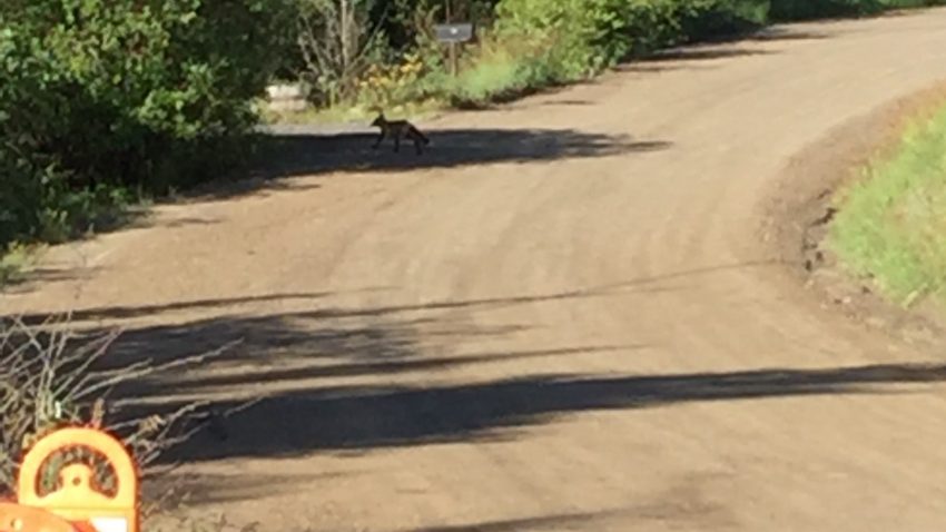 n an easy rhythm. The gradient continued on for about 12 miles, with not much of a chance for your legs to recover. To make it even more exciting, I was chased by a fox at mile 4, which, silly me, chose to outwit the fox by sprinting away. Just in case you think this is crazy, I snapped a picture of the fox as he lost interest in me. It worked, but also put me into the red for a while. It was similar to the scene in “American Flyers” when they were sprinting with “Mike”. For the next few miles this occupied my mind wondering what would possess a fox to chase a bike. Having gotten my mind back to the task at hand I continued to climb through the switchbacks and the lovely alpine terrain. It is important to focus on getting your body into a rhythm to be able to sustain this long effort. There is nothing quite like hearing a babbling stream and the wind through the Aspen trees. As I continued to climb, it gradually warmed up and started to strip off layers. At mile 12 you hit a slightly steeper ramp and you pop around a corner to grab an absolutely gorgeous view of Echo Lake. The view also gives you another view of Mt. Evans in the distance. When you get past Echo Lake at you can feel the temperature start to cool off a little bit. In only a
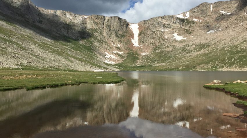
 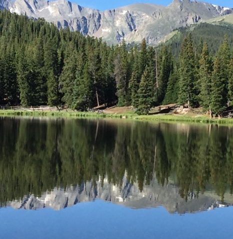 few short miles you will leave the beautiful alpine landscape and enter the moon like terrain as you exit the tree line. The elevation now measures 10,579 feet, but the rhythm still feels comfortable. Vegetation ranges from lower spruce-fir and lodgepole forests, through 2,000-year-old Bristlecone pines and krummholz near the tree line, to delicate alpine vegetation reaching all the way to the highest peaks. Some of the Bristlecone pines are ancient and up to 2,000 years old. The road levels out for about 1/2 mile, which is enough to let you shake out your legs and that extra lactic acid. The Echo Lake Lodge is a good place to replenish your water bottles, which is at the entrance to the park. You now turn right on Highway 5 into the park. As you cruise past the toll booth the next few miles ramp back up to about 6% as you continue to cruise through the tall pines. As the forest begins to thin, you can now see the road up ahead and your mind starts playing tricks on you as you begin to think it is a really long way to the summit, but you are now well over halfway to the top. As you focus on the task at hand, the climb begins to feel steeper, which also plays on your mind, but it is really the altitude talking and not that little voice in my head. There is no lack of distraction as you continue to grind up the mountain. After you’ve passed the bristlecones, all that’s left are a few unfortunate krummholz trees, which look quite barren and have been exposed to the harsh conditions. Shortly thereafter the trees disappear entirely. At that point, it’s just you, lichens, grass, extremely hearty wildflowers and I was promised some wildlife (pika, marmots, mountain goats and bighorn sheep). So far outside of the fox not another animal was spotted. As you round the next switchback, there is a little descent, that takes you down to Summit Lake. Another gorgeous view and you now realize that the views of the lakes alone are worth the trip.
 At Summit Lake, there is a small parking lot and a small shelter, but there are no services available, but I notice a lot of people in cars cheering me on or stare in wonderment at seeing a cyclist on a bike at 13,000. From this point, there are only five miles, 15 switchbacks, and 1,300 feet of climbing left. This is when the climb started to become a bit desperate on my part. Cycling at this high of an elevation is like nothing you may have experienced as the lack of oxygen is now the foremost thought on your mind. I was told after this climb, by my friend who is a pilot for FedEx that they have to wear oxygen masks over 10,000 feet in non-pressurized cabins. As you continue above the tree line, it turns out you are completely unprotected, and the sharp winds kick in. The temperature has dropped by 10-15 degrees, so the jacket comes back on which I am glad I tucked it under my jersey. At about 13,500 the summit observatory comes into view, and it looks tantalizingly close. Adrenaline kicks in, and I start to pedal faster only to realize that I am now gasping for air. My heart rate monitor indicates that I am still at a comfortable 130 bpm but being challenged to get enough air in my lungs, I slow my pace. I chug up at least a dozen more switchbacks and then realize on more switchback and I will be in the parking lot. That last switchback seems like a 30% grade, but it is still only 7-8%, but with the lack of oxygen it makes for an extremely difficult last push. As the grade eases up, I can now easily pedal to the summit. Still no Mountain Goats. I guess I will have to come back to search for them next time. The views from the summit are beyond amazing. As it turns out it was really not the summit, you had to climb up
 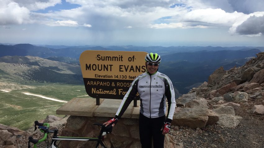 that mound of rubble to be able to say you made it all the way to the summit, but as far as cycling, I reached the end of the highest paved road in the U.S. After several photos and even being ask to snap a picture of a family who was on vacation. Clearly this will be their Christmas Card. They were a bit hesitant to ask if I would mind being in a photo with them, because they felt that no one would believe them when they tell their friends that some people cycle up Mt. Evans. I guess I may be in there Christmas Card, I hope they don’t forget to send a present. After a short time at the summit, the weather report was calling for rain, and I noticed that it was already raining in the distance, it was time to go. Not having put much thought into the descent, I figured it would be a breeze and very cool ride. After all, how hard could 27 miles downhill be. Let me just say that it took over 3 hours to complete the climb, but only 55 minutes for the descent. The descent was a bit harrowing as there are no guard rails on much of the road, with some really steep and long drop offs, but not to worry, I had my super grippy tires. It was an amazing 54-mile journey and I was glad to have completed my first 14er.